 Athens and Ankara Publish Conflicting Maritime Boundaries
A new front has opened in the long-standing maritime disputes between Greece and Turkey; this time, they fought not with ships but with conflicting maps. In a move exacerbating regional tensions, Athens and Ankara have almost simultaneously published official documents outlining their respective Maritime Spatial Planning (MSP) strategies, revealing starkly divergent claims over the Aegean Sea. While both sides frame their publications as technical planning exercises aligned with EU directives, the conflicting boundaries significantly escalate the 'map war' over sovereign rights in the contested waters, providing a complex and intellectually stimulating topic for international relations and maritime law enthusiasts.
Turkey's "Blue Homeland" Deepens:
According to the Turkish newspaper Milliyet, Turkey is finalizing its national Maritime Spatial Planning (DMP) study. The associated map, developed by the Turkey Maritime Spatial Planning Platform linked to Ankara University's National Research Center for Maritime Law (DEHUKAM), defines Turkey's maritime boundaries based on what it terms "scientific methods and international law." Crucially, Milliyet reports that the map uses the "median line" calculated strictly between the Greek and Turkish mainlands as the boundary in the Aegean Sea.
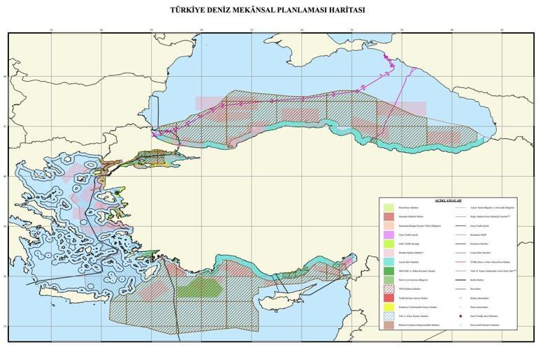
Source: Milliyet
Dr. Mustafa Başkara, Director of DEHUKAM, told Milliyet that this approach aligns with international law and conventions as a "reasonable solution." He stressed, however, that the map "does not constitute an official, legally binding maritime jurisdiction boundary" for the state but is a "scientific and legally compliant study." This work, Başkara noted, is a "concrete indicator of Turkey's effort to build a scientific vision for its 'Blue Homeland' vision," aiming to maximize the economic and geopolitical potential of its surrounding seas. Milliyet also adds that Turkey plans to do MSP work similarly to that of the internationally unrecognized Turkish Republic of Northern Cyprus (TRNC).
Greece Defines "Potential Outer Limits":
Concurrently, Greece announced its National Spatial Strategy for the Maritime Space (ΕΧΣΘΧ), detailing its own Maritime Spatial Planning (ΘΧΣ), as reported by Greek news outlet News. The Greek initiative, led by the Ministry of Environment and Energy in cooperation with the Foreign Ministry, is presented as a necessary step under EU Directive 2014/89/EU to organize maritime activities.
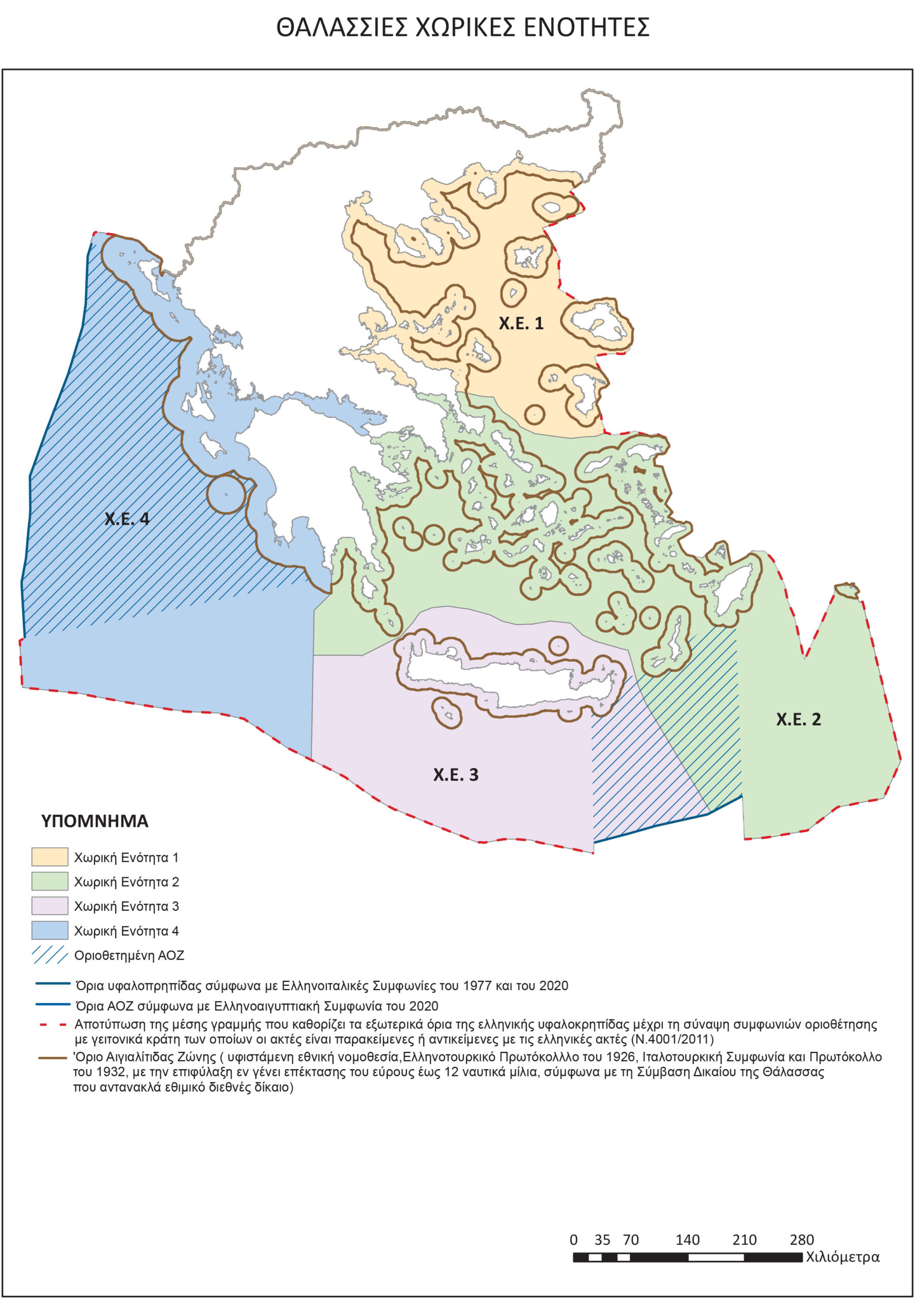
Source: Newsit
According to Newsit, citing government sources, the Greek map is significant because "for the first time in an official EU text, the potential outer limits of the Greek continental shelf" are depicted. This implies giving full effect to Greek islands in determining maritime zones. While the map incorporates existing delimitation agreements (with Italy and Egypt), for undelimited areas like much of the Aegean and Eastern Mediterranean, it reportedly uses the median line principle – but calculated based on the presence of Greek islands, thus extending far beyond Turkey's mainland-to-mainland calculation. Greek officials, quoted by Newsit, emphasized that this map is not a formal EEZ delimitation or an extension of territorial waters (a right Greece reserves) but rather a planning tool defining areas for activities based on sovereign rights derived from international law.
Conflicting Visions Solidified
The simultaneous release underscores the fundamental conflict. While both nations utilize the term "median line," their interpretations and applications diverge dramatically. Turkey's mainland-to-mainland approach drastically limits Greek maritime zones in the Aegean, reflecting its long-held position and challenging the impact of islands. Greece's map, conversely, depicts expansive potential zones based on the principle that islands generate continental shelves and EEZs, aligning with the UN Convention on the Law of the Sea (UNCLOS), which Turkey has not ratified.
A Cartographic Confrontation
Although Athens and Ankara present their maps as technical planning frameworks rather than immediate, formal border claims, their simultaneous publication crystallizes deeply conflicting legal and territorial visions for the Aegean Sea. This 'map war' signals a hardening of positions, creating official reference points for incompatible claims. While Greek sources cited by Newsit maintain a desire for positive relations and Turkish sources reported by Milliyet label their map 'scientific' rather than officially binding, the publication of these dueling cartographies injects fresh contention into the sensitive Greco-Turkish relationship, potentially complicating future dialogue and heightening the risk of disputes in the already volatile region, underscoring the gravity of the situation and the need for international attention.